
Place Names, Potteries, Collieries, Brickyards: a collection of maps showing industrial sites and place names from bygone days by John Foulkes: a map of place names of old Buckley "
Buckley
2004
see 146.5 for "Place Names" in "Buckley 'Board' 100 not out" by Leslie Rowlands.
see 124.4 for main entry
Some of the hotspots have been slightly altered from the map's text to fit in with the rest of the archive.
*******************
Some notes to
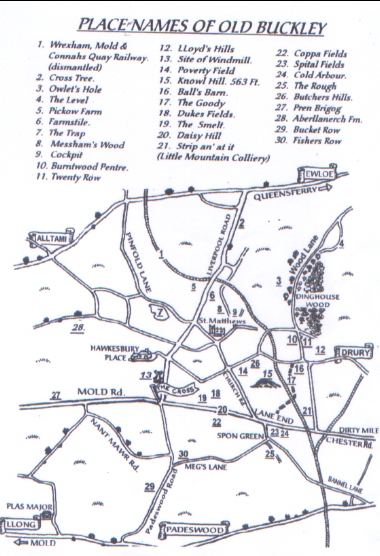
PLACE-NAMES OF OLD BUCKLEY
The oldest place-name listed in Buckley is recorded in William the Conqueror's Domesday Book of 1086 as
Biscopestreu which means Bishop's tree. We know it today as Bistre.
In 1302 Buckley appears as Bokele which means 'a clearing for bucks (male deer)
in a wood' The spelling of place-names during their history often changes dramatically, as does
Alltami i.e Galltamy, Allt Amy, Alltamy, and during the early Victorian period,
Altamy.
Just as place - names change, so does their locality or position. If one looks at Bannel Lane on fairly recent Ordnance Survey maps and also on Victorian maps then you will see that Bannel Lane was in fact the lane that runs from the bottom of Bannel Lane (as we know it now) to the Dirty Mile. This passed Bannel Farm on the right. Now, Bannel Farm is south of the Mold to Chester road at Padeswood and of course Bannel Lane runs to Lane End.
The Spital Fields is one of those places that seems to have changed location or maybe its just memories playing tricks. Thomas Cropper suggested that a hospital lay adjacent to Cold Harbour in the days when the latter may have been a monastic hostel and the name comes from that. Currently, anyone who has any inclination of the position of Spital Fields would place it south of Spon Green.
Cold Harbour (or Arbour as some spell it including Victorian maps) was, according to
Thomas Cropper, a place of refuge, which was cold, windy or bleak.
If one consults a good dictionary for the meaning of Arbour then you will find that it
means; 1. A bower formed by trees, shrubs or vines;
or 2. A grass plot; lawn; garden or orchard.
I think I would prefer one of the latter meanings.
The name Coppa Fields and Coppa View don't seem to have an adequate explanation. Good old Thomas Cropper suggests that Coppa comes from a Welsh word 'copa' meaning top or crown but that wouldn't explain the name of Coppa House between Padeswood and Pont Blyddin which is right along side the river Alun. Maybe Coppa fields and Coppa View have that name because they overlook Coppa colliery at Padeswood and Coppa House which is a little further on.
When one sees a name'-------- Row' as in Fishers, Bucket, Twenty, etc., then this usually refers to a terrace of small houses built to house the families of colliers etc in days gone by. There must have been thousands of these terraces all over the country and one wonders how many still exist. If any still do exist in their original form then wouldn't it be a good idea to do them up and preserve them as reminders to future generations of how we used to live. Or has this already been done.
JF
MAP TEXT
Place-Names of Old Buckley
1. Wrexham, Mold and Connah's Quay Railway
2. Cross Tree
3. Owlet's Hole
4. The Level
5. Pickow Farm
6. Farmstile
7. The Trap
8. Messham's Wood
9. Cockpit
10. Burntwood Pentre
11. Twenty Row
12. Lloyd's Hills
13. Site of Windmill
14. Poverty Field
15. Knowl Hill. 563 ft.
16. Ball's Barn
17. The Goody
18. Duke's Fields
19. The Smelt
20. Daisy Hill
21. Strip an' at it (Little Mountain Colliery)
22. Coppa Fields
23. Spital Fields
24. Cold Arbour
25. The Rough
26. Butchers Hills
27. Pren Brigog
28. Aberllanerch Fm.
29. Buckley Row
30. Fishers Row
Author: Foulkes, John
Tags
Year = 2004
Document = Map
Landscape = Urban
Extra = 2000s
Copyright © 2015 The Buckley Society