
Saxton's County Map: Fig.1 in 'When did Buckley become a Town?' by Neville Dunn"
Flintshire
1607
Written November 2004
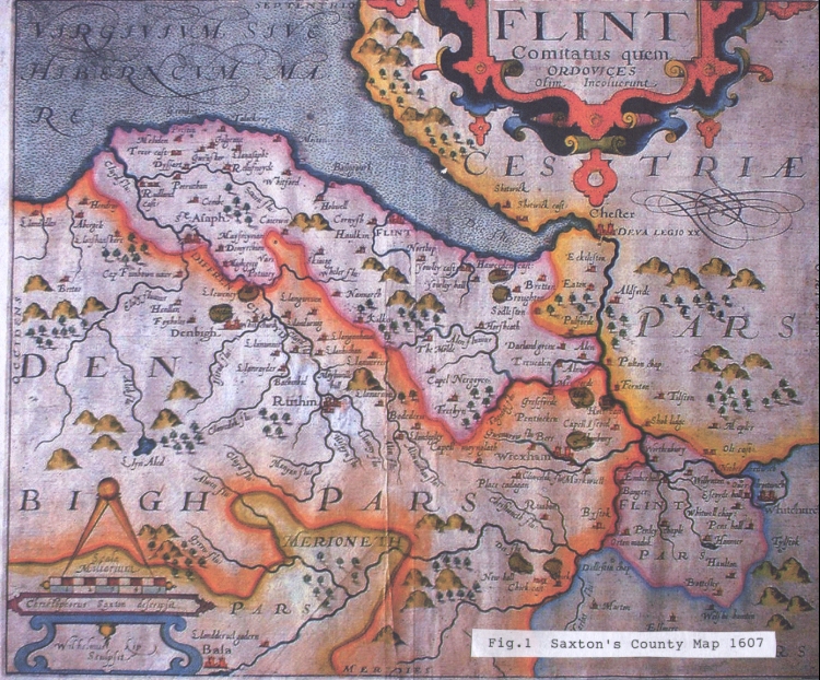
Fig. 1 Copy of Christopher Saxton's Map of Flinthsire dated 1607 from his County series as drawn by William Kip
WHEN DID BUCKLEY BECOME A TOWN?
As a schoolboy I had a passing interest in maps because of the geography lessons but this interest became much keener when I left the Alun School in 1947 to start work as a junior in the County Land Agent's Department of Flintshire County Council. The council owned 2400 acres of small farms scattered over the county from Talacre in the north to Fenn's Bank, Whitchurch in the south including those at Prenbrigog, Myrtle Road and Nant Mawr in Buckley.
The boundaries of these farms were recorded on plans traced from Ordnance Survey Maps and I was soon learning to draw them myself Then in the late summer of 1947 I was given the job of recording all the wayleave agreements over the farms indicating where overhead electricity lines had been allowed to cross the land. This entailed going to Rhostyllen to the offices of the North Wales Electricity Company, shortly to be nationalised as MANWEB, where I pored over 25 inch Ordnance Survey Maps for many days and thus began my lifelong interest in the Ordnance Survey.
In 1955 I transferred to the County Architect's Department of the county and began to take part in building designs. By 1969 I was switched from Further Education designs at Kelsterton to designing libraries and fire stations in preparation for changing to metric measurement in 1971. The last imperial measure fire station proved to be the new Buckley Fire Station, comments about which I have recorded elsewhere. In wanting to discover the history of the building site in Brunswick Road, then occupied by Liverpool House, I visited Hawarden Record Office to check what had been recorded in earlier days. I knew from talking to old Buckley residents that Buckley had grown quickly as an industrial community in the 19th century with quite a chequered history but I was interested in going further back in time.
As a wedding present in 1959, I had been given an original copy of Christopher Saxton's map of Flintshire drawn by William Kip in 1607 (see Appendix Fig.1). This showed a blank space between "The Molde" in the west, Broughton in the east, "Horsheath" (Hartsheath, Pontblyddyn) in the south and "Yowley Castle" (Ewloe Castle) in the north. There was not even an indication of hills as there was for Halkyn Mountain. Other small villages were however shown - "Tryddyn" (Treuddyn), "Capel Nergoyce" (Nercwys), "Kilken" (Cilcain), etc - showing their lengthy existence.
At Hawarden, I saw a survey map dated 1800 showing the extent of the enclosures of Buckley Common gained by Squire Davies (a predecessor of the Davies-Cooke family) under an Act of Parliament. There was little to see in the way of a settlement - just a scattering of cottages on Buckley Mountain with no sign of Liverpool House in its former guise at The Duke of York Inn.
I was also shown a copy of a survey map drawn in 1820 which showed proposals for improving the road from Mold to Broughton by way of Padeswood and Penymynydd - the present A5118. The map extending as far north as the "existing Mold to Broughton Road" running over Buckley Mountain - the present A549. More development was now shown along this latter road especially in the stretch covering the present Brunswick Road and including a recognisable Duke of York Inn, thus confirming my guess that the inn was named after George III's son.
I did nothing more to investigate early Buckley until I recently looked at a copy of the Ordnance Survey's first attempt in 1840 to show Britain in more detail than Saxton had done (see Appendix Fig.2). This map is a reprinting of an engraving made in 1883 after the railways (including the Shotton extension of the Wrexham Mold and Connah's Quay Railway) had been added to the original 1840 Map details first in 1869 and then later for the Hawarden Loop to Shotton.
This map showed many roads and other features that are still recognisable today and there was of course the windmill which gave Mill Lane its name. But there was no Bistre Church, yet to be built, and it appeared that, if there was a settlement, it lay between Lane End and Alltami on "Buckley Mountain" with Buckley Church marked at its centre. Several modern communities were recognised on this OS map by their church's name rather than their present name, eg "St Marks" was Connah's Quay, "Trinity Church" was Gwernaffield and "Christ Church" was Pontblyddyn. Thus the small community on Buckley Mountain was probably known as Buckley Church for reference purposes but the title was given no more importance by the surveyors and cartographers than titles for "Pren-brigog" and "Little Mountain".
The next map I looked at was the result of the Ordnance Survey's greater mapping efforts in the 1860's after which they published the first really detailed maps of Britain in 1870. This time roads, railways, fields and buildings were shown in fine detail, an example to the rest of the world which still keeps us today in possession of far better maps than any other country. The example shown (see Appendix Fig.3) is the 1870 First Series of the Six Inch OS Map which, at a scale of approximately six inches to one mile, was detailed enough to show individual fields but still at the same time cover a sizeable village or town on one sheet.
Buckley was now more recognisable in 1870 as a community with its two churches, two schools, its crossroad and its industrial development. There is still however a strong emphasis of the "Buckley Church" settlement from the 1840 Map, with the only pub names for instance being shown in that area - the Horse & Jockey and the Gladstone Arms in Church Road and the Royal Oak, Prince of Wales and Cross Keys Inn in Lane End. "Buckley" as a settlement title was still given little importance positioned in small lettering across the Higher Common area compared with the large lettering of the four parish titles - Ewloe Wood, Ewloe Town, Argoed and Pentrobin. The parishes were of course still important administrative organisations at that time particularly with regard to the poor law, but they were soon to lose their ancient highway maintenance duties to the new Highway Boards.
The Ordnance Survey had carried out a resurvey in the 1890's and drawn their first updating of the 1870 maps in publishing the 1900 series (see Appendix Fig.4). This version of the six inch map gave the new titles for the two parishes - "Buckley-Mold" and "Buckley-Hawarden" and, with the passing of the Local Government Act, a title was now shown for the first proper local government organisations as we knew them, "Buckley U.D." representing Buckley Urban District Council formed in 1898. "Buckley Mountain" was now confined to a minor description for the area of the three commons, while "BUCKLEY" as a proper town title was indicated adjoining The Cross. So, with its population now beginning to catch up with the adjoining county town of Mold, the town of Buckley was thus given due recognition at last.
APPENDIX
List of attached illustrations
Fig.1 Copy of Christopher Saxton's Map of Flintshire dated 1607 from his
County series as drawn by William Kip. (this entry)
Fig.2 Copy of the Ordnance Survey's first national survey map at a scale
of 1 inch to 1 mile dated 1840. (96.24)
Fig.3 Copy of the Ordnance Survey's first national survey map at a scale
of 6 inches to 1 mile dated 1870 but updated to include railways as
they existed in 1888. (96.25)
Fig.4 Copy of the Ordnance Survey's revised national survey map at a
Scale of 6 inches to I mile dated 1900 after District Councils had been
created. (96.26)
Author: Dunn, Neville
Tags
Year = 1607
Document = Map
Event = Historic
Landscape = Cultivated
Extra = Pre 1900
Copyright © 2015 The Buckley Society