
Buckley Society Magazine Issue Three: The Sandycroft Wooden Way by James Bentley: map 1"
Sandycroft Wooden Way, Drury
July 1975
Buckley Society Magazine Issue Three, July 1975
see 28.301 for contents etc.
see 1.596 for maps 2 and 3
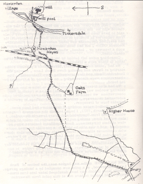
Map one Drury to Hawarden
THE SANDYCROFT WOODEN WAY
SOME TIME BEFORE his death, Mr Harold Gregory had discussed with me the possible routes of a wooden way which was said to have been made in the eighteenth century to carry coals from collieries in Buckley to the river Dee at Sandycroft. He had searched documents and other materials at the Flintshire Records Office, but had been unable to ascertain the route of such a tramway or, indeed, whether it had ever been fully constructed.
Consulting notes left behind by Mr Gregory, I decided to attempt to trace such a tramway, if it had existed.
We had sometime previously, investigated a possible route starting at Drury and passing down Slack Lane, serving the Pentrobin Smelt and then proceeding down Tinkersdale. The observations were discouraging, no evidence of a tramway being found.
We had also travelled to Glyndyfrdwy to take a look at the existing wooden way (of a later date) and as a result of our observations we realised that a graded tramway required quite substantial causeways, embankments and cuttings to provide a reliable form of transport.
In our limited walks nothing of this nature had been seen.
In early March, 1972, I began to walk the numerous footpaths which extend from Burntwood and Drury towards Hawarden. I also walked them setting out from Hawarden in order to get a view of them in reverse. Soon significant features were recognised and I was able to identify a possible tramway route with continuous alignment from certain points in Buckley down to Hawarden Mill and from Moor Lane, Hawarden, to Pentre, Hawarden.
The examination of maps and documents has not revealed any evidence of later tramways, roads or carrying routes to account for the features which mark out this as a well-found way.
THE MAIN LINE of the way begins near the bottom of Bank Lane, Burntwood, at a point now occupied by a haulage garage. Feeder lines (which may have developed later into iron tramways), would appear to have met at this point from Hawarden collieries (in the Little Mountain area), from Lloyd's Hills, Sandycroft Colliery and Pentrobin smelt.
Proceeding northwards along the present alignment of a footpath, the main route descended gently as a shallow way alternating between cuttings and embankments. About half a mile along, evidence of a cutting about five feet deep extends for about eighty yards. Most of the route along this stretch constitutes a hedgerow, and is obscured by hawthorn and holly. Investigation of the undergrowth revealed in places several disintegrated lengths of timber. One piece of timber was retrieved and placed in our open-air museum. This specimen bears evidence of three holes for spacing or fastening supports. A fine specimen of a stone block, with a round hole, and the remains of a broken block, were also found.
At a point marked on the 1912 0.S. map as a 'lime-kiln', the well-defined way becomes obscure, but it would appear to have followed the line of the present footpath, which veers easterly for a hundred yards and descends across a tilled field to a brook. The foot-bridge no longer exists, but dressed stones are embedded in the bank and bed of the stream, suggesting the former existence at this point of a passage over the water. No evidence of any other crossing of the stream could be found when a considerable distance of the stream bed both above and below this point was examined.
Beyond here there is a short stretch of farmland which has been well-cultivated over a long period.
I continued along the footpath until I reached 0aks farm and then, turning left, I skirted the premises and Proceeded along the farm track to Hawarden Hayes. About 150 yards along, the track passes a gateway leading into the Hawarden Golf Course. Entering this gate (on the left-hand side) a prominent embankment, curving anticlockwise, proceeds for several yards before entering a shallow cutting. This gradually merges into the well-kept golf course, but its alignment to a hedge about eighty yards to the south-west can be traced.
This hedge delineates a shallow embankment which merges into the adjacent field on the south, but aligns to the crossing point of the stream previously referred to, about a hundred yards at the opposite side of this field. Hence the route appears to link up.
CONTINUING TOWARDS HAWARDEN the way fellows the present cart-track to a point just above the railway bridge, which appears on the right. Here an alignment veers towards the railway line and would have continued eastwards beyond the railway previous to its construction. The probable path of the tramway can be seen as a rut alongside a hedge which approaches the Tinkersdale ravine. It runs parallel to, but about a hundred feet higher than the leet from Hawarden Hayes farm to the bottom of Tinkersdale,
Ready permission to walk over the land was given by Mr Newport of Hawarden Hayes.
The tramway route appears to deviate from the cart-track at a point about eighty yards above the railway over-bridge, and would cross the path of the railway at a point by the lower of two signal posts near to this point.
A prominent cutting descends the field to the east of the line and this swerves due east about sixty yards above the farm buildings. Following the continuous hedge of bushes, it enters Tinkersdale just below a disused sandpit and descends as a deep cutting to the bank of Broughton brook. The lower section of the descent is obliterated by a later sandpit
The sandpit workings confuse the possible course of the way for a short distance, as do the many rebuildings and widenings of the main road in this area over the years. At this point, however, a hard way bears right at the river bank, and fifty feet further on joins a track from another sandpit. Both then cross the brook by a two-arched bridge. Remains of one of the arches are still to be seen - it is lined with Buckley bricks. Sections of the arches still existent would show it to have been about eighteen feet wide, and crossed by a thick causeway of soil, gravel and slaty material.
The track then joins the present main road at a gate.
THE ORIGINAL WOODEN WAY, however, would appear to descend to the left. There is evidence of a cutting running parallel to Broughton brook and disappearing at the point it meets the culvert carrying Groomsdale brook. Sections of this cutting revealed a base of coal and cinder fragments.
Many recent roadworks have been constructed over a period of time and have obliterated traces of the tramway in this region. But there is a continuation of the way on the other side of the road, commencing near the track to the mill. It appears to have run on the west side of the mill dam and to have passed under the roadway leading to the sluice, to arrive at a point near to the entrance of the mill. One observes traces of a deep, narrow cutting, quite separate from old water courses and in line with the path of the wooden way. This cutting would have emerged just above the mill and continued along the hill slope on the north side, now a well-cultivated park-land.
The whole length of the way up to this point appears to be continuous and well-defined. It would appear to emerge from the castle estate near the top of Moor Lane and near to this point, to merge into a track which has been improved at later dates and has been used for more sophisticated types of rail transport.
Author: Bentley, James
Tags
Year = 1975
Month = July
Document = Map
Transport = Streetcar
Work = Transport
Extra = Pre 1900
Copyright © 2015 The Buckley Society