
Buckley Society Magazine Issue Two: Old Buckley Tramways by James Bentley: article and map"
July 1971
Buckley Society Magazine Issue Two, July 1971
see 1.322 for Part One in Issue One
OLD BUCKLEY TRAMWAYS PART TWO
QUITE A number of footpaths in the Buckley locality are of solid foundation under foot, considering the slimy, 'clayey' sub soil which predominates. Hedgerows, especially in the Drury and Lane End areas, often, until recent building and development schemes obliterated them, were here and there flanked by long, pieces of L-shaped iron plating. Many stiles were constructed of L-shaped iron crosspieces and a solid burnt clay stepping block.
Closer examination would identify these objects as long discarded tramway line and stone sleeper blocks. The solid footpath was in fact the ancient site of a tramway.
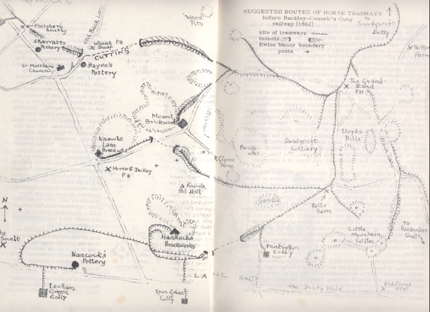
On following the alignment or direction of some of these courses, one finds that they obviously do not form part of the layout that terminated at the Knowl Hill sidings on the Buckley to Connah's Quay line, which dates from 1862. They are much older. They represent the original iron, or even wooden ways which served long forgotten and even unrecorded coal workings and which linked up with a road-head (on an existing hard road) or descended the whole way to the river Dee. Most of these appear to link up with the Sandycroft tramway, at points much lower down than the present derelict wharf by Buckley Old Station.
Bearing these observations in mind, an attempt was made recently to map out and investigate possible routes of ancient tramways which may have existed in east Buckley.
AVAILABLE MAPS show tramways linking Catherall' s Trap brickworks with the Willow, Oak, Ash and Elm colliery group, and proceeding along the Tram Road to the Horse and Jockey, and then over Mount hill by way of Drury Lane and alongside the Knowl Hill (or New Mount) brickworks to the siding near Knowl Hill. These tracks can hardly be original courses, as the standard gauge railway did not reach Buckley until at least seventy years after tramways commenced up here.
A small footpath bears off Etna road (the old Back Lane) to the right near the cottage which was once the Wheatsheaf inn. This footpath is still known as the Cutting. If a tramline once ran down it, even this line was preceded by an earlier one which ran through a tunnel under or near the path of the Cutting. This tunnel commenced on the opposite side of the Etna road from the inn, near the clay ponds of Hayes' pottery, and passing under the road, proceeded probably parallel to the Cutting on its left hand side for about eighty yards, emerging roughly where the Cutting ends. I had this from Mr J. Catherall (aged 82), of Spon Green. The tramway then veered past the site of the present gasworks to join the main route near the Grandstand.
Most probably this line was the original one to serve Catherall's works as well as Hayes' and Sharratt's potteries. There is much evidence to show that a tramline began at the Old Trap works and passed behind Ewloe Place . In the fields behind the houses there is a shallow cutting. The line of this reaches Liverpool Road near Fletcher's smithy, and reappears on the other side of the road as an embankment which crosses the field below Hill farm towards a point at the bottom end of St Matthew's churchyard, near the tunnel mentioned above. This causeway has a brick surface about the width of the tramway gauge. No metal rails have been found along it, but this structure, similar to that of the horse tramway near Knowl Hill, suggests that it probably had L-shaped plates.
The original line from the Mount brickworks appears to have linked up opposite the Grandstand, having come down the Mount Pleasant road past Woods colliery (which was near Pentrobin chapel) and the Sandycroft colliery, which gave its name to this tramway system.
The road from the Pentre past the Parrot inn is still known by old residents as the 'rail-road'. Along it ran another line which came from works in the Lane End and its neighbourhood. Proceeding past the Parrot, it probably crossed the road and carried on along the raised pathway over the Goodie.
Before this line reached the Goodie pit, a branch turned off it and bore up a slope on the right. It passed through what is now the centre of Buckley Old Station platform and thence along the rear of the Glynne Arms. Continuing upwards it crossed a later tramline (which ran from the Mount works down to Hancock's sidings) and turning towards the Mount works it entered a deep cutting in a sandy outcrop. Today it finishes abruptly in the hillside. At the entrance to the cutting a bridge carried a later tramline overhead, joining the Knowl Hill brickworks (the New Mount) and the Mount brickworks. Maps of the 1860s would suggest that the older tramline tunnelled under the hill, known as Butcher's hill, and emerged on the west side of the Mount brickworks to serve the Knowle Lane brickworks and perhaps coalpits on the Common and beyond.
THE FEASIBILITY of the remains of a long-forgotten tunnel under Butcher's Hill led to the writer investigating this cutting. Initially the site was quite unapproachable. The floor of the cutting was deep in water, mud, decayed vegetation and thistles. A thick network of saplings was reinforced by thickets of gorse.
Approaching from above by way of the later tramline which once passed over the now nonexistent bridge, I descended into the morass, and systematically drained the site over a period of several weeks. Maximum periods of one to three hours could be spared at any one time. On the water level between the abutments of the bridge being lowered, several bulky shapes became visible. These proved to be burnt clay blocks of various designs, all related to the furnace or chemical manufacturing processes. Several flat iron rods and sections of the original bridge handrail were brought out. Numerous broken furnace doors or damper plates were present as well as a burnt clay plate engraved with the letters GAZ. Crumbling pieces of timber could have comprised parts of a shipping box.
A concentrated conglomeration of industrial clay ware of such magnitude suggested that a train load of goods descending from the Mount works ran out of control, crashed through the bridge and fell into the tramway below.
Such a mishap was probably the straw that broke the camel's back, in that it may well have so damaged the bridge as to lead to the abandonment of the tramline for an alternative route already established.
Immediately above this site, the floor of the cutting was explored, and L-shaped tramway plates were discovered. They were mounted on wood sleepers, 5'9" long and 9', wide. The gauge was 42". About twelve feet further up from the bridge, a sleeper was unearthed, which bore two sets of nails (but no rails attached), and indicated the commencement of another set of tramlines The sleepers were embedded in a firm matrix of fine clinkers and coal dust, which appeared unaffected by the long immersion under water.
Further up, about twenty-five feet from the bridge, a brick-made floor commenced. This extended across the clearing, which here widened to a triangular space, twenty-five feet along each side. The brick setts bore sunken depressions to hold the tramlines along the right hand side of the triangle. No traces of a left-hand tram branch were found, but the site was not fully investigated. Remains of two tram sleeper blocks lay in the undergrowth. Small sections of rail in the depressions curved right and into a steep sided ravine above the clearing. At the top end of the triangle the depressed track terminated on the inside against a wooden sleeper. The line on the outside continued, but constituted the track of a narrower gauge of 30".
Beyond the neck of the ravine, the cutting widened and showed signs of slight sand workings. Intermittent traces of wooden sleeper and occasional iron rail were encountered. Diggings were made at the extremity for signs of a tunnel. Denudation of the sandy slopes made the task extremely difficult and no positive results were obtained. A hog-backed ridge in this spot looks promising, however, as the outer skeleton of a tunnel. Any chance of tracing the continuity of the line on the opposite side of the hill is impossible because of extensive excavations for clay which have resulted in the Mount pool.
That this branch tramway is of extreme antiquity and of one-time importance must be deduced from the abundance of workings and from the superimposing of a wider gauge in the low section.
BESIDES TAKING ADVANTAGE of favourable gradients, ownership of intervening land and the possible spoilage of existing deposits had to be considered in laying a tramway. Many seemed to hug the side of existing rights of way, and others the line of boundaries. Several boundary posts fringe some of the Buckley tramways. Ewloe Manor boundary posts are often seen.
When a proprietor or company owned more than one works, as in the case of Hancock's, a common branch line would have its linkages with the several works; but each separate owner had his own independent through-way, which avoided or tunnelled under possible obstructions, legal or physical.
Coalworkings in the Standard and Mount Pleasant Colliery and Etna areas appear to have had an outlet by the line descending north-eastwards, joining the main line near Aston Hall colliery. Alignments may be traced near the Standard clayhole and at the rear of Paradise farm. (A copse of trees alongside is riddled with what appear to be bell-pit workings) Old collieries in the neighbourhood of the later Aston Hall colliery, although only a stone's throw from the Sandycroft tramway, do not appear to have used this outlet. A separate tramway ran from this area to Queensferry (as the Aston Hall colliery and brickworks later had their own line to the river).
The Sandycroft tramway appears to have turned abruptly eastwards in this neighbourhood, and near the bottom of Wood Lane turned along the Kearsley ravine (behind the Hawarden secondary school) before veering northwards , past the entrance to Hawarden Golf Club to a point at the rear of Bernie's garage on the Highway. Here it plunged downwards in a tunnel (as I was informed by Mr E.Taylor, now retired, of Oaktree Farm, Padeswood). It emerged at the edge of the recreation area surrounding Truman's Hill. Passing the rear of the present Masonic hall, it veered north-eastwards above Daniel's Ash, negotiated an impressive, high embankment alongside Mancot colliery before crossing the fields to Sandycroft ironworks, where a wharf existed on the
riverside.
ALTHOUGH the tramways were private property, there can be no doubt that the firm, dry way provided a means of foot communication for many people along its route. That this route was a recognised road up to Hawarden is indicated by the inscription on a tombstone of the early nineteenth century which is to be found in St John 's Congregational churchyard. This reads:-
'Mr Sellars of Chester and a few friends came in a boat
to Sandycroft, then up to Hawarden to preach, where
he was shamefully abused. Bad eggs thrown at him.'
ADDENDA
1. Close examination, shows that another line came to join the tramway system near the Grandstand. It came from the Little Mountain colliery and other workings in that area by way of a route passing near the present church of the Good Shepherd.
2. A smelt existed in Pentrobin during the later years of the eighteenth century and into the following century, and Mr Griffiths, a farmer in the locality, informs me that one of his fields bears the name Smelthouse field. It is believed that coal from the Sandycroft colliery was the source of fuel for this manufactory, but no evidence of a tramway is recorded.
During the Easter vacation of 1971 Miss Susan Jones, a university student, of Pentrobin, reported that L-plate tramlines had been unearthed during digging operations near her home. Examination showed the existence of three such rails in very poor condition, as well as the presence of a tramway block.
This block was different from previously-examined specimens in that the centre of the upper surface bore a square depression, at the centre of which a round hole was sunk. This type appears to be a far more stable and sophisticated block than the type used on the Sandycroft tramway, in that a metal plate occupied the recess and on it rested the rail, which was then secured to the block by a nail in a wooden plug. The alignment of these rails and their situation would appear to confirm the existence of a tramway in this locality.
A 'wooden-way' from Sandycroft colliery through Hawarden is reported as traceable in parts by R.J. Dean in his booklet on Flintshire railways, and the map he provides has a route which might well correspond to the location of the iron rails found in Pentrobin.
It would be interesting to suggest that this wooden-way was superseded by a tramway which served the Pentrobin smelt and continued down Slack Lane, Tinkersdale and Broughton Brook to Hawarden.
Author: Bentley, James 1
Tags
Year = 1971
Month = July
Document = Journal
Landscape = Industrial
Transport = Streetcar
Work = Transport
Copyright © 2015 The Buckley Society