
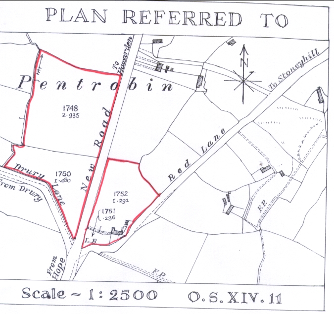
Plan of smallholding taken from the Ordnance Survey map to accompany tenancy agreement"
New Road, Pentrobin, Buckley
1908
The area outlined in red marks the boundary of the smallholding and is not on the original plan.
See 65.68 for the 1908 and 1920 tenency agreements between Alfred Connah and the Hawarden Estate. See 65.64. and 66 for photos of the cottage
L.B. in field 1750 was a brick-built letter box.
PLAN TEXT
Scale - 1:2500 O.S. XIV.11
A SMALLHOLDING IN PENTROBIN OWNED BY THE HAWARDEN ESTATE.
The plan shown is a replica of the type of tenancy agreement plan that would have been hand drawn in the Hawarden Estate Office by tracing over the 1899 Ordnance Survey Map before attaching a copy to the agreement document.
The tenancy of this smallholding was taken over by Alfred Connah, the grandfather of Buckley Society archive team member, Mary Lewis, who has described what the property looked like when her family lived there. The house was a simple, stone walled cottage with a thatched roof and a slated lean-to kitchen extension and bedroom on the back. At just over five acres, it didn't provide a living and her grandfather worked on the Hawarden Estate as a forester in the extensive woods.
What stock he had was housed in a small shippon on the end of the cottage in Welsh "long house" style and in a pigsty and other small outbuildings. The property didn't have a formal proper name but apparently was simply known locally as "Thatched Cottage".
The cottage and garden stood on the end of a lane next to a junction with the main road to Hawarden (now the A550) and with the end of Drury Lane opposite where a post box (LB = letter box) was fixed which, according to the Connah family, was the meeting place for the three policemen serving Dobshill, Drury and Hawarden to discuss the state of crime, etc. The lane was known locally as Red Lane because at that time it was surfaced with red shale from the brickworks before eventually being tarmaced. Red Lane connected with the original main route between Hope and Hawarden, running through an area called Stoneyhill and later became known as the Old Hope Road as it is so named today. Red Lane was so called as it was made of red shale - broken bricks and pots etc - to try to improve the surface. It was tarmaced in the mid 1930s. (Mary K. Lewis - I can remember being told off coming home covered in the red dust having spread it all over my clothes after falling in it!)
The straight section of what is the present main road cut through the smallholding land and, being known as "New Road", was the end of a new highway that was driven through to Tinkersdale, probably by the Road Commissioners before Flintshire County Council became the highway authority at the end of the 1890's. The new road bypasses the narrow and twisting section of Old Hope Road and the plan shows how the small fields lying each side of the straight "New Road" match boundaries and were originally two larger fields.
After the Connah's tenancy came to an end, the cottage was sold by the Hawarden Estate in the early 1980's and has been completely renovated and extended, losing its thatched roof in the process. A subsequent occupier has named it "Providence Cottage".
Virtually all of the original smallholding now lies under the large roundabout and flyover forming the junction between the A55 Expressway and the A550 Queensferry to Wrexham road and Old Hope Road was severed by the construction. The short piece on the Dobshill side of the roundabout on which Providence Cottage lies is, after the efforts of a local Councillor, now called Serenity Lane.
Author: Dunn, Neville
Tags
Year = 1908
Building = Domestic
Document = Map
Landscape = Cultivated
Extra = 1900s
Copyright © 2015 The Buckley Society