
Buckley Society Magazine Issue One: Old Buckley Tramways by James Bentley"
1970
Buckley Society Magazine Issue One, July 1970
Fig.1. - 1.581; Fig.2 - 1.582; Fig.3 - 1.583; Fig.4 - 1.584 and 1.585; Fig.5 - 1.585; illustrations - 1.586 to 1.589
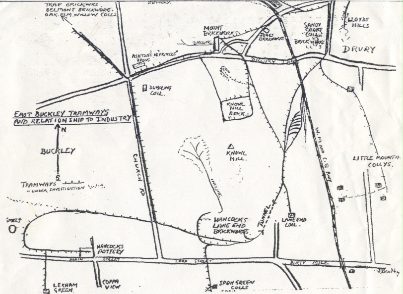
Please note that Drury Brickworks was named Sandycroft Brickworks on this map. See 1.159 for name changes of this brickworks.
See 1.591 for Part Two of the article in Issue Two
OLD BUCKLEY TRAMWAYS
The presence of coal and clay in the Buckley area was known from early times. That its use could not be exploited was due to a large extent to the uneconomical methods of obtaining it, to existing timber still clothing the area, and lastly to the fact that coal had not been of wide use in manufacturing or in smelting processes prior to the eighteenth century.
Small surface workings of coal in the Burntwood and Drury area would produce coal to be sent to Chester in 'pytches'or in panniers slung across the backs of horses. And coal was thus an expensive and select commodity. The distance to Chester was only eight miles, but the treacherous, clayey subsoil of this vicinity and the boggy waste of Saltney marsh made it impossible for carts or carriages to proceed direct. It was more practical to descend the shorter slopes to the River Dee at Golftyn or to Sandycroft, and to transfer stocks of coal to boats. (Fig 1) This opened an export market to Liverpool, North Wales and Dublin as well as Chester.
The introduction of a tramway or wooden way, consisting of two narrow parallel tracks of wooden boards along which carts could be drawn revolutionised the mineral industry in Buckley (and in the county of Flint). One of the earliest of these 'wooden-ways' in Wales proceeded from Mancot to the river and this was followed by one from Sandycroft up to the Sandycroft colliery in Drury. Wooden track was superseded by iron rails, which, because of their strength, only required supports at their joining points. (Fig.2)
In open country, these sleepers consisted of stone blocks. A hole was bored in the centre of the upper, flat surface, a plug of wood was inserted and the iron rail was nailed to the block.(Fig.3) Remains of these rails and their stone blocks are frequently encountered in Buckley. Existing tramway still in position may be found in the vicinity of Knowl Hill between Drury bridge and Hancock's Lane End brickworks.
Different varieties of rail were in use. In Buckley two types of original form may be seen. These are 'L' shaped and 'U' shaped. (Fig.4)
Large exchange and marshalling sidings were constructed on the eastern slopes of the hill. Branches proceeded across Butcher's Hill to the Mount Pleasant brickworks and along the Tram Road to serve Catherall's and other brickworks and collieries. Another branched off to the Lane End collieries, another to the chain of Little Mountain collieries, whilst the main road proceeded under a curved tunnel into the Lane End brickworks. Branches went to Spon Green, Lexham Green and to Hancock's pottery on Daisy Hill.
The Buckley Railway Company opened a standard gauge line from Buckley to Connah's Quay in 1860. It commenced adjacent to Hancock's sidings on Knowl Hill and finished on the quay side at Connah's Quay. This made the upper part of the tramway redundant,and the feeders only proceeded to the (new) Buckley station.
The small tram-trucks were run direct onto standard railway trucks in batches of four, and were unloaded at the docks. Seven small curved branches backed end-on to the coal wharf where empty wagons were waiting. Remains of tram wagons existed on Knowl Hill sidings until about ten years ago, along with decaying transport wagons.
The Buckley tramway may have been unique, in that large stretches were wholly supported by bricks. The glut of inferior bricks, unsuitable for sale, may have accounted for their use in this connection. The siding network was actually embedded
in brick, thus ensuring a very firm, stable rail-bed.
Examination of the site reveals an intricate and apparently much duplicated network of points and loops. The switches would be worked by the wagon man, and consisted of an iron pin on a swivel. This could be kicked or levered over to the 'correct' road. An unusual point existed until recently at the sidings. (Fig.5) This unit entered as a double track and diverged to four tracks. The outside branch nearest to Buckley, led towards the Mount, the New Mount and the Trap brickworks. The next constituted the original line to Sandycroft. Then a branch went to serve the seven curved bays. The last one ran along the perimeter of their terminal.
The tramway tunnel curved slightly, and in order that horses with their trains should not meet in the single track tunnel, a semaphore was constructed. A loop-line existed and is still traceable on the Drury side. Returning empty trains waited there until the track was clear. This tunnel was provided with ventilation shafts. Entry could be gained through one as recently as July 1969.
A tavern with associations with the tramways was the 'Grandstand', Burntwood, which was demolished as recently as last October (1969). The tramline from the Mountain over Drury Lane met the tramway from Knowl Hill near the tavern before proceeding down the Dinghouse wood to Aston Hall. A door in the inn was adjacent to the line and this provided an easy means whereby colliers and carters could obtain drink unnoticed before rejoining their loads. It was nicknamed the 'Tram Door'.
The illustrations to the above article and the drawing of Hancock's Siding were by the author. Mr Bentley also drew the barrows to be found elsewhere in the book.
Author: Bentley, James
Tags
Year = 1970
Document = Map
Landscape = Industrial
Transport = Streetcar
Work = Transport
Extra = Pre 1900
Copyright © 2015 The Buckley Society