
Buckley Urban District Council Offices and Free Library"
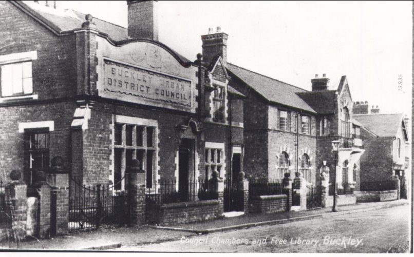
Buckley Town Council Offices, Mold Road, Buckley
1910
Beating the Bounds or walking the Bounds
BUCKLEY URBAN DISTRICT COUNCIL
In the notes in this file there are several references to the old custom of 'Walking the Bounds', but no one has given any mention of where the boundaries were.
In the 1930's there was a boundary review which moved the district's southerly boundary to its present position, taking in parts of Padeswood. I don't know the exact line, but the old south boundary ran behind the properties on Meg's Lane and Spon Green before this review.
As has been mentioned in the notes, the Urban District was formed by the amalgamation of two Civil Parish's, Buckley Mold and Buckley Hawarden and this distinction lasted for some purposes (and might still exist) such as Court proceedings and drinking licences until after I finished work. For General Rate recovery purposes I had to prepare separate summons lists and attend two separate Magistrates' Courts, depending on the address of the properties concerned.
The boundary between the Parishes ran along the 'Boundary Brook' from a point somewhere in the fields behind Aberllanerch Farm, crossed under Mill Lane near Hawkesbury and continued in a piped culvert (which got blocked by tree roots) across the front of St John's Congregational Church and Sunday School. It then continued in a more-or-less straight line to within a few yards of Brunswick Road and Church Road - where Linthorpe Gardens now stand. Here the ditch went underground again. I don't know its exact route but it passed under the Crown Vaults public house on Chester Road, along the backs of properties on Chester Road and Brook Street as far as Bistre Methodist Chapel, where it passed under Spon Green and continued again behind Bannel Lane properties to our Urban boundary near Bannel Railway Bridge.
This boundary caused problems at the Crown Vaults as some public rooms were in Buckley Mold and others, licensed for different hours, in Buckley Hawarden.
We had a similar problem with the Urban Boundary near Bryn-y-Baal. Here the boundary ran along the centre of Bryn Road from the Alltami Brook to Top Farm, Bryn-y-Baal. Buckley was responsible for the road and properties on the south side and Holywell Rural for the north side. When the road needed resurfacing, Buckley attended to the lower half of its length and Holywell did the rest.
From Top Farm the southbound boundary was Colliers Fields footpath until it met Mold Road. Here again both Councils were each responsible for their own side - Holywell collected bins from the Mold side and Buckley from ours. This was fine until Top Farm land was sold for development and both Snowdon Avenue and Llewellyn Drive straddled the boundary and one house in each of the cul-de-sacs linking them from both sides was built half-and-half in each authority! This was remedied in the latest review when part of Bryn-y-Baal was 'swapped' for part of Alltami.
The old Buckley U.D.C. boundaries are best shown on the map in the first Official Guide to Buckley issued in the 1960's. From Colliers Lane (mentioned above) the boundary did a little zig-zag across Mold Road then followed a lane and ditch which skirted Bod Offa Farm, crossed Well Street close to Bistre Farm and headed towards Bryn Faigas Farm following a brook which crossed lower Padeswood Road by Garreglwyd and the main A5118 road near Padeswood Station. From here, the boundary became the railway line for about ¾ mile behind the Cement Works when it turned more northerly, recrossing the A5118 to Bannel Bridge. Little Mountain Road then became the boundary between Buckley Urban and Hawarden Rural Districts, crossing Buckley's main road A549 at The Mile railway bridge and heading along a field footpath to the bottom end of Drury Lane. Here again Buckley had split responsibilities up to and along Bank Lane and along the edge of Ding House Wood (now built upon). From here, the boundary became a straight line on the map to Liverpool Road railway bridge. From here, the old railway line through several brickworks took over as far as a level crossing beyond the Old Castle Brickworks, where Alltami Brook resumed its duties up to Bryn Road (mentioned earlier).
Author: Hayes, John Eric, 1918
Tags
Year = 1910
Building = Public
Landscape = Urban
Work = Office
Extra = 1910s
Copyright © 2015 The Buckley Society